
To fully understand the ice storm rating system you must read all of the information below. (The snowstorm scale can be found at the bottom of this page)
During the upcoming winter season I will once again be using the Sperry-Piltz Utility Ice Damage Index to give an indication of the severity of significant icing events. This is an experimental rating system and should be used for planning purposes only.
Our region has become no stranger to significant icing events. A major ice storm struck the Ozarks of Missouri during the winter of 2007. A major ice event produced significant damage across portions of Missouri, southern Illinois, and western Kentucky in the winter of 2008. Then in 2009 a catastrophic ice event struck portions of Arkansas, Missouri, Illinois, and Kentucky.
There are several pros and cons to this rating system. It is important to remember that even a light freezing drizzle event can cause hundreds of accidents in any given county.
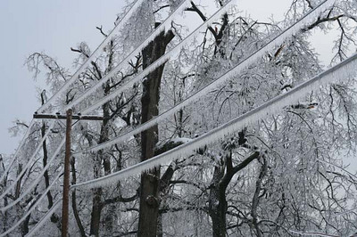
Ice does not have to accumulate to significant levels to be dangerous. The ice storm rating system will be ineffective for these light freezing drizzle/rain events. The index is not meant to be a determining factor in road conditions. This system is only useful for determining infrastructure impact. In other words - the damage potential to power lines and trees.
Studies have shown that this tool has been effective when used properly by emergency management and those in decision making occupations.
The ice storm rating system is only as effective as the accuracy of the forecast. Remember (and I say it many many times during the winter season) that winter storm forecasting is extremely difficult. A winter forecast can even change while an event is underway. The difference between freezing rain and cold rain is only one degree. During the 2009 ice storm we were 1-2 degrees away from not having a catastrophic event. The bust potential (inaccurate forecast) of ice storm forecasting is always high.
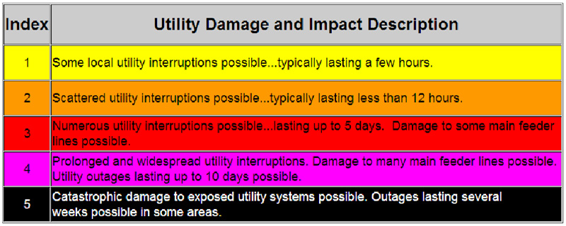
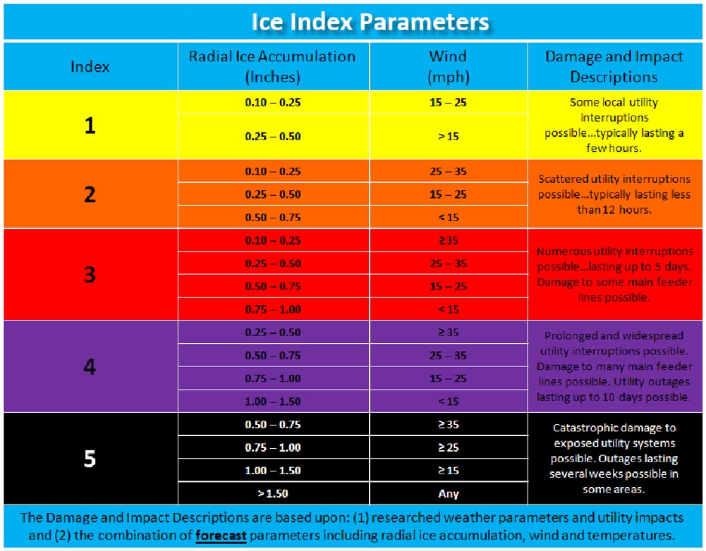
The Sperry-Piltz Utility Ice Damage Index categorizes damage potential in five levels through the use of radial ice thickness and wind speed. Utility systems may be able to handle moderate ice accumulations, but stressed lines under wind forces are more likely to break. Therefore, one inch of ice may be a level 2 or level 3 ice event, but if wind speed exceeds 25 mph, it becomes a level 5 event.
This will be the second year that I am using this ice storm rating system in our emergency management forecasts. This rating system is not officially being used by the local National Weather Service Office and should not be confused with any product or products that they issue. The same is true of the snowstorm rating system. As always, I work closely with the NWS and other local and national meteorologists to provide the most accurate forecast. We all work as a team to provide the most timely information to you. When there is differing opinions on a forecast then I will convey that information in my blog postings and emails. Forecasters don't always have to agree - but we do try to convey a uniform message. Our interest is your safety.
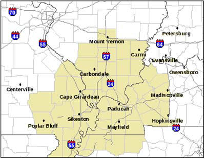
The forecasted rating of an ice storm will be my forecast opinion based on all of the data available. This forecast, although will be widely read, will be for specific counties and I will state those counties in the forecast (you can also view the counties that I usually forecast for on the map at the bottom of the page).
Forecasts will vary from one county to the next. During the 2009 event Johnson County, Illinois did not have anywhere near the amount of damage that Massac County (one county south of Johnson County) and McCracken County experienced. Graves County, Kentucky had severe damage compared to areas one county south in Tennessee.
Again, although this won't be a perfect system it should provide all of us with another tool in the decision making process in order to be better prepared for the next ice event. The forecast won't always be correct - no forecast ever is - and we know this up front. Ice storms are extremely difficult to forecast. However, it is better to be prepared than unprepared.
Using this scale, the 2009 ice storm was forecast to be a category 5 event. That forecast was accurate. The 2008 ice storm that struck Massac County, IL would have been rated at level 3 and 4.
The scale for the rating system can be viewed below in jpeg format. If you have any questions then please contact Beau Dodson.
![]()
References - View Study Here
Remember that every winter storm is dangerous. Ice and snow covered roadways, whether 1/2 inch or 16 inches, can cause dangerous driving conditions. During the last two years nearly 1000 people have been killed on icy roadways. See Icy Road Safety.com for more statistics.
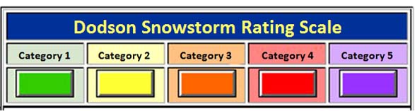
Dodson Snowstorm Rating System
Category 1 SnowstormAccumulation: Snowfall accumulations of 1-4" are forecast. A fairly common event.
Life Threat Level: Low threat to life if residents use care and caution when venturing out. Remember that any roadway that is slick can be dangerous. Nearly 1000 people were killed during the last two winters from accidents on slick roadways.
Travel Impact: Roads may become slick. Use caution.
Economic Impact: Little to low economic impact is expected.
Advice to Emergency Officials: Expect normal snow related operations. Listen for updates from the NWS and local media.
Category 2 SnowstormAccumulation: Snowfall accumulations of 4-8" are forecast.
Life Threat Level: Some threat to life if caught out in the storm without an emergency kit or proper supplies. Use caution if you must travel. Elderly residents should use caution. Residents with heart conditions should use care if they must remove snow from sidewalks or driveways.
Travel Impact: Roads will likely be slick and hazardous. Some difficulty for light weight and small vehicles – especially with snowfall totals of six inches or greater. Caution is advised. High winds can cause blowing and drifting of snow - especially in rural areas.
Economic Impact: Low economic impact.
Advice to Emergency Officials: Extra staff may be necessary during the peak of the event. Otherwise normal snow related operations are to be expected. As always, listen to NOAA Weather Radio and local media for updates.
Category 3 SnowstormAccumulation: Snowfall accumulations of 8-12" are forecast.
Life Threat Level: Some threat to life if caught out in the storm without an emergency kit or proper supplies. Travel is not recommended during peak of storm unless an emergency or roadways are plowed. Elderly residents should use caution. Residents with heart conditions should use extreme caution. A few tree branches and power lines may break if the snow is wet.
Travel Impact: Travel is not recommended until roadways have been plowed. Until the snow is removed there will be significant travel difficulty for light weight and small to medium sized vehicles. Moderate to high winds will cause considerable blowing and drifting snow.
Economic Impact: Moderate economic impact. Some businesses will likely close for short periods of time.
Advice to Emergency Officials: Extra staff will likely be needed during the peak of the storm. Towns and cities may have significant piles of snow that will need to be removed. This is especially true of events with greater than 10 inches of snow. As always, listen to NOAA Weather Radio and local media for updates.
Category 4 SnowstormAccumulation: Snowfall accumulations of 12-16” are forecast. A rare and unusual event.
Life Threat Level: Snowstorm poses a substantial threat to life. Those who venture out in vehicles can expect extreme difficulty. Elderly residents should stay indoors. Residents with heart conditions should use extreme caution. A few structures with large roof spans may collapse under the weight of the snow - especially if heavy sleet or heavy wet snow occurs. Some tree branches, trees, and power lines may break if the snow is wet. Power outages possible if the snow is wet. Significant threat to livestock and other outdoor pets/animals.
Travel Impact: Travel is not advised. Some road closures will be possible. Interstates and highways may be closed in some areas. For most vehicles and trucks, travel will be nearly impossible, until roadways are plowed. Towns and cities should expect travelers to be stranded. Some motorists may attempt to abandon their vehicles. Airport delays and/or closures will be possible. Towns and cities will likely require major snow removal operations – including the use of dump trucks to haul away snow. Anyone who absolutely must travel should notify friends and family of their travel plans. Carry a cell phone at all times. Moderate to high winds could cause significant blowing and drifting snow.
Economic Impact: Significant or major economic impact. Many businesses, malls, large colleges, and government agencies will be closed for one or more days. Hotels may quickly fill up with stranded travelers. Some counties may need sheltering operations.
Advice to Emergency Officials: Extra staffing of all operations will likely be necessary. Emergency officials are urged to talk to their local media before the storm hits – advising residents to prepare for a significant winter storm event. A local state of emergency declaration may be required in some counties, towns, and cities. Emergency personnel may need to plan on spending the night at facilities or may find themselves stranded at their place of employment. Four-wheel drive transportation may be necessary for essential personnel workers. As always, listen to NOAA Weather Radio and local media for updates.
Category 5 SnowstormAccumulation: Snowfall accumulations of 16” or greater are forecast. Historic or near historic event.
Life Threat Level: Serious/significant threat to life and property. Extreme caution is urged – travel will be nearly impossible. Elderly residents should stay indoors. Residents with heart conditions should use extreme caution. Anyone venturing outside should notify friends and family of their plans. Carry a cell phone. Some structures will large roof spans may collapse under the weight of the snow - especially if heavy sleet or heavy wet snow occurs. Numerous tree branches, trees, and power lines may break if the snow is wet. Power outages will occur if the snow is wet. Extreme threat to livestock and other outdoor pets/animals.
Travel Impact: Travel is not recommended and will be nearly impossible until the snow is removed from roadways. Numerous road closures will likely occur. Interstates and highways may be closed. Cars may be abandoned on interstates and other roadways. Travel will be nearly impossible for vehicles and trucks. Airport delays and/or closures will likely occur. Towns and cities will require major snow removal operations – including the use of dump trucks to haul away snow. Anyone who absolutely must travel should notify friends and family of their travel plans. Carry a cell phone at all times. Moderate to high winds could cause significant blowing and drifting snow.
Economic Impact: Major to extreme economic impact. Many businesses, large colleges/universities, and government agencies will be closed for several days. Many or all school districts will be closed for several days. Hotels may quickly fill up with stranded travelers. Some counties may need sheltering operations. A local state of emergency declaration may be required in some counties, towns, and cities.
Advice to Emergency Officials: Extra staffing of all operations will be almost certain. Emergency officials are urged to talk to their local media before the storm hits – advising residents to prepare for a significant to extreme/historic winter storm event. Emergency personnel may need to plan on spending the night at facilities or may find themselves stranded at their place of employment. Four-wheel drive transportation may be necessary for essential personnel workers. National Guard units or large four-wheel drive vehicles may be necessary to help local emergency officials respond to emergency calls. Shelters may be necessary to house stranded motorists. As always, listen to NOAA Weather Radio and local media for updates.
* Keep in mind that schools in this region have been known to close before snow even begins to fall. So, I did not include any guidance for the potential of school closings (other than large colleges and universities).
** High winds during any of the above categories could cause any given forecast to produce more adverse impacts than the category states. Each individual event will need to be evaluated - it is possible than an event could be upgraded because of sustained high winds causing blowing and drifting snow.
For more information on Illinois winter storms please visit the Illinois State Water Survey web-site.
Confidence in the Forecast?
I will also be using a confidence meter during the upcoming winter storm season. This is modeled after the Capital Weather confidence meter. I added the probability numbers to better express the meaning of low, medium, high, and very high. You will find this meter mentioned in my emails or on my weather analysis blog posting. My daily analysis can be found by clicking here.
![]()
Areas that I usually forecast for or cover in my discussions. I will, when asked, forecast for other areas in Kentucky. The snowstorm rating scale is specifically made for the counties highlighted below.